
Looking Up the Owners Around a Boone County Property
Finding nearby owners works parcel by parcel. The WV Property Viewer finds a starting address fast. Each parcel opens an assessment card. The card lists the owner name and mailing address recorded on the tax roll. Plats and tax maps explain lot relationships when boundaries look confusing. Boone County property records of this kind answer a land question. They are not a census of who occupies the block.
| Source | What It Shows About a Block | Access |
|---|---|---|
| WV Property Viewer | Parcel outlines, location, and detail link for nearby taxable lots. | State map viewer |
| Assessment roll | Owner(s), mailing address, parcel identity, and annual property details. | State assessment search |
| Recorded plat or deed | Lot calls and legal description supporting a boundary relationship. | County Clerk records |
| Historic map or book | Older lot names or tract context when a modern address is absent. | Archives or map collection |
The owner of record may live elsewhere. The assessor's card reflects who holds the land, not who occupies it, and tax mail may go to another address entirely. Rentals, vacant lots, and estates widen that gap. So do family transfers and LLC deeds. Treat the result as a land-record answer, and resist using it to guess at anyone's private household.
Mapping a Boone County Block's Owners
Begin with an address you can recognize easily. Find its parcel on the map first. Then study the lots touching or near it. The viewer offers Parcel, Address, and Flood Zone search modes, plus Details, Highlight, Copy Link, and Download KMZ controls for working with what you find. Remember that it maps tax parcel references, so it works as a lookup aid rather than a survey-grade measuring tool.
- Search the street address in the WV Property Viewer and zoom until the selected parcel and nearby outlines are legible.
- Open Details for each parcel of interest; record the parcel identifier and the assessment link.
- Read the assessment card’s Owner(s), tax year, and mailing address for that specific identifier.
- Compare the legal description or recorded plat when a boundary, road, or shared line matters.
- Parcel ID
- The county and district map key used to link a mapped lot with its assessment record.
- Adjacent parcel
- A lot that appears to touch another on a map; confirm the legal boundary when precision matters.
- Tax map
- A reference drawing used for assessment and parcel identification, not a survey.
- Owner of record
- The person or entity shown on the assessment card for its stated tax year.
Privacy Limits on a Boone County Neighbor Lookup
A neighbor search can surface names in land records. It cannot tell you who lives in a building. Assessment cards show owner and address fields, and the public parcel layers stick to taxable land. No layer publishes private contact or security details. Keep it that way in practice too: never pair a parcel result with unrelated data to guess at someone's routine or household.
Lawful use. Use a Boone County neighbor lookup for parcel context, boundary questions, or ordinary property research. Using owner information to harass, threaten, or intimidate a person may violate West Virginia law.
What a Neighbor Parcel Detail Can Show
Open one parcel at a time. The viewer's detail panel ties a selected tax parcel to an owner name, address fields, flood information, assessment values, and a link to the full assessment record. Exact fields vary by parcel and state data. Labels crowd together in dense blocks and can overlap at small scale. Keep the identifier with each note. The West Virginia parcel viewer supports parcel, address, and flood-zone searches. Controls include a detail view and a KMZ download. A KMZ helps compare several parcel locations in mapping software. The state's tax mapping layer remains the source.
The detail panel identifies a neighboring parcel. Verify its owner and year on the linked assessment card before relying on either.
Rural Boone County Parcel Neighbors
Rural Boone County does not line up in tidy blocks. One property may border a long tract, cross a hollow, or neighbor land reached only by a private road. A dot close on screen is not always an adjoining legal parcel. Check the district and parcel identifiers first. Read deeded acreage and tract calls too. A creek, ridge, or right-of-way can matter to the legal description even where the web map draws a simplified line. Sample assessment cards show why neighboring parcels must stay distinct. A Boone County Commission parcel card can carry an E-911 address beside deeded acreage, calculated acreage, and building cards. Those fields identify a record well. None of them fixes a surveyed boundary on the ground. For a closer look, the Boone County Commission sample parcel card shows how assessment details attach to an identified parcel. It is a record view, not a survey.
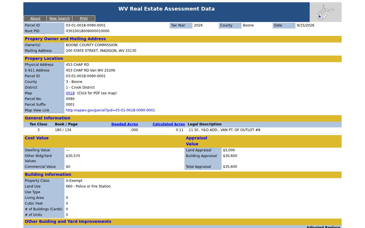
A disputed line calls for the recorded deed and a qualified surveyor. Never settle it with a displayed outline.
Madison Lots and Neighbor Research
Madison's tax map records include Map 8. Map 8 also covers the C&A, Shields, and Crawford & Ashby Additions. Addition and lot names orient a block search when street labels have changed. They also help when a plat defines the parcel. Madison Map 8 carries a date of October 31, 1963. Its scale runs one inch to one hundred feet. The map is explicitly tax-purpose material, useful for record navigation. It does not settle fence lines or boundary disputes. For each lot, note the map number and parcel key. Then search that key in the assessment system. If a lot's shape or name disagrees with the modern viewer, compare the recorded plat and deed wording before trusting either. Context helps here. The Boone County parcel map guide covers map interpretation and source limits.
Saving Neighbor Lookup Results
Save what you find, parcel by parcel. A short record with the map link, parcel ID, and owner field as displayed lets you retrace your steps. Include the tax year as well. Add the mailing address when it matters, plus the date you opened the card. A question may turn on a shared drive, boundary, access route, or subdivision lot. Store the legal description or the book and page citation too. That habit makes a neighbor comparison reproducible even after annual assessment data changes.
Treat names as record labels, nothing more. The data proves no personal relationship between owners, no actual occupancy, and no for-sale status. The real question is about land rather than the map display. The deed or plat is usually the next document worth pulling. For verifying one parcel's owner, see who owns a Boone County property.
Boone County Neighbor Map Layers and Update Timing
The state viewer offers three search modes: Parcel, Address, and Flood Zone. A flood layer answers its own question. It will not tell you who owns the next lot over or whether two parcels share a boundary. For ownership, select the tax parcel first and open its assessment detail. For flood exposure or a boundary decision, rely on the authoritative map or a qualified professional. Do not settle for a parcel outline.
Refresh timing varies by record type. The state updates general parcel and assessment data on an annual cycle, while delinquent tax information moves weekly. Neighbor names, value details, and delinquency status can therefore carry different effective dates. Keep the card's tax year and the date of your map view with your notes. A recent deed may be recorded before the next annual roll update lands. The map can lag further behind a split or correction.
Stale card? Compare the recorded deed and the prior parcel key. Then ask the Assessor about the roll or mapping status. A map refresh schedule never guarantees an instant change after a closing. The current owner record guide explains how the deed date and assessment year can diverge.
Timing gaps matter most in a block-wide review. A list built from several parcels may mix records from different cycles. Treat each owner name as a dated record. Note whether it came from the assessment card, the tax account, or the deed instrument.
The viewer's documented controls cover selecting, highlighting, inspecting, and exporting a parcel. Boone County offers no dedicated neighbor-radius or automatic adjacency report. Build a block list the manual way: inspect the surrounding polygons and open each detail card. If the display gets crowded, copy a link or download the KMZ for a stable reference view. Then match the selected parcel IDs against the assessment results.
Do not confuse "nearby" with "touching." A parcel across a road, stream, or right-of-way can sit close by. Yet it can carry a different legal relationship. When the question involves shared access, drainage, an easement, or a boundary line, pull the deed or plat. For a precise location, bring in a surveyor.