
How to Search Madison Property Records
Boone County treats Madison parcels like every other parcel in its custody. Open the state assessment search. Enter an address or owner name. The card that comes back shows the district, map, parcel, suffix, and legal description. That key opens the rest. Use it in the deed index for transfers. Use it in the Sheriff Tax Office for ticket status. Or use it in the WV Property Viewer for the mapped parcel. City permit and zoning history is different, because Madison offers no searchable permit portal. That question goes to the city directly.
- Search the address or owner in WV Property Assessment and copy the parcel ID from the matching Madison card.
- Use the Boone County Clerk index to locate a deed by party name or instrument reference.
- Check the Sheriff Tax Office ticket for the applicable year and payment status.
- Open the parcel in the state map viewer and compare the legal description with the card.
- Contact Madison for a municipal document or permit question; its public archive does not function as a parcel permit database.
The Boone County property search guide explains the assessment fields. The parcel map guide covers map identifiers. Neither changes the fact that Madison parcels are filed in Boone County and state systems.
Where Madison Property Records Are Kept
Boone County offices hold the land records. The County Clerk records deeds and other instruments. The Assessor keeps parcel and valuation cards, and the Sheriff Tax Office handles tax tickets. State assessment and map applications put county data online. Madison's city office holds plans and ordinances, but the city publishes no searchable, address-indexed permit or zoning system.
Boone County Records (deeds, taxes, parcels)
Use the state assessment application to find a Madison parcel card and its county parcel key.
Madison Additions and Subdivisions in the Records
Addition names on Madison's tax map index can tie a current lot to older plats. They can also tie it to older deeds. Madison Map 8 lists three. They are C&A Addition, Shields Addition, and Crawford & Ashby Addition. Treat them as map references. They are not a full list of neighborhoods, and they do not date construction. Copy the addition and lot wording exactly as a search clue. Then confirm the recorded plat and parcel description.
| Neighborhood / Subdivision | Era | In the Records |
|---|---|---|
| C&A Addition | Shown on Madison Map 8 | Match lot label with the deed and parcel key. |
| Shields Addition | Shown on Madison Map 8 | Use the addition name as a plat search clue. |
| Crawford & Ashby Addition | Shown on Madison Map 8 | Compare map lot wording to the recorded description. |
An address that returns nothing useful may still yield to an addition name paired with an owner or parcel number. The plat label can point to a lot reference. It cannot prove a present boundary. The Boone County parcel map guide explains why recorded descriptions and survey evidence control questions that need boundary precision.
What Madison Property Records Show and Their Limits
A county assessment card can show an assessment owner, tax year, mailing and physical addresses, parcel key, acreage, and valuation fields. Deeds document recorded transfers and legal descriptions. Tax tickets show billing and payment status. Map layers place each tax parcel on the county grid. Municipal plans and ordinances may add context. None of these records alone is a title opinion, a survey, a market appraisal, or proof of who occupies a building.
Lawful use. Use Madison property records for property research, due diligence, and civic transparency. Do not use owner information to stalk, threaten, or harass a person.
Reading Madison Map 8
Madison Map 8 carries a date of October 31, 1963. Its scale is one inch to one hundred feet. The title and legend call it a tax map. That makes it handy for linking addition names, lot labels, and county parcel references. It is not a boundary survey. Do not set a fence or a corner from it.
A map number may show up on an assessment card. Compare the lot shape and label with the deed's legal description. A modern street address may look different on the older map. Keep the map date with your notes. That habit helps a later reader. It tells the 1963 sheet apart from current state parcel data.
Boone Court House Became Madison
Madison was once called Boone Court House. The town took its present name in 1906. That switch matters for old deeds, plats, and local histories. A document may name the place Boone Court House even though the parcel now lies in Madison. Search both names when the instrument date is old. Then confirm the tract description, district, and adjoining calls before tying a record to a present property.
The name change moved nothing between governments. Deeds and tax assessments still sit in Boone County's systems. For old ownership work, follow book and page citations in the county deed index and the Archives finding aid. A city archive cannot stand in for the recorder.
Madison’s Municipal Document Archive
Madison’s public documents collection spans a 2023 comprehensive plan. It also includes older business-license, floodplain, service, and ordinance material. These files give useful city-level context. However, the city publishes no address-indexed building permit portal and no dedicated zoning-case search. A visitor with a property-specific permit question should contact the city directly. The request should describe the address, parcel, and type of record needed.
The City of Madison sits at 255 Washington Avenue. It lists (304) 369-2762 as its phone number. Those details work well for a direct records question. They should not be confused with the Boone County Clerk or Assessor. Those offices control county land records such as deeds and the parcel tax roll.
Browse the Madison documents archive for municipal publications. Then ask the city whether a separate file exists for the property.
A Madison Assessment Card Example
A Madison assessment card packs a lot into one page. The Owner(s) field sits beside mailing, physical, and E-911 addresses. Also listed are book/page, acreage, legal description, and the appraisal figures. Why does this matter? A name alone rarely separates two similar Boone County parcels. Copy the full PID and tax year. Do this before you open the Clerk index or check a neighbor parcel.
The Madison sample assessment card shows the format the county uses. Treat it as an illustration. Values and owner names change. Verify the current parcel record before relying on any figure.
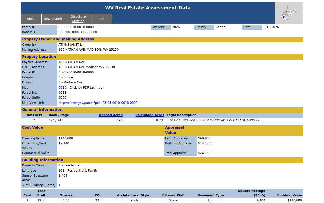
Match the year and the parcel number shown on the card before drawing any conclusion. Those two details tie each example field to the real Boone County property record.
Madison Mailing and Parcel Addresses
A Madison mailing address names the post office, not the government. Postal city labels say nothing about incorporation. They say nothing about zoning jurisdiction or which records office holds the file. The mapped tax parcel can spill past a municipal boundary. The mail still routes through Madison. So work from the parcel map, the tax district, and the legal description first. Then bring your question to whichever government actually has the authority to answer it.
The assessment card lists three separate fields: Mailing Address, Physical Address, and E-911 Address. The first handles correspondence. The second locates the site. The third follows emergency-addressing records. When they disagree, keep all three. Ask the custodian for the correction rather than swapping one address for another in a deed search.
Tracing Older Madison Property Records
Old houses reward patience. Start with the current legal description. Walk the chain of deed grantors and grantees backward through time. The Archives finding aid covers Boone County deed index entries from 1847 through 1968. Filmed deed books run from 1847 through 1910. Surveyor books and historical land books add tract context around those deeds. Their date ranges mark record series, not a promise that every page is searchable online.
Expect older references to use Boone Court House or an addition name. Some use a bare tract description instead of a street number. Record every book and page citation you find. Compare the parcel wording from one deed to the next. When the online index runs out, request the volume or reel you need. The county former owners guide walks through this backward chain in more detail.
Madison City Limits and Boone County Parcel Records
A Madison mailing address settles very little on its own. It does not prove the parcel sits inside the incorporated city. Postal geography, a community label on a map, and a county tax district are three different identifiers. Mixing them leads to wrong answers. For city services, permits, or ordinances, confirm the parcel's jurisdiction with Madison directly.
Ownership questions follow a different route. Boone County parcel records turn on the parcel ID and the legal description. These remain the practical search keys for assessment and tax history. A parcel can carry a Madison mailing city. Its record trail can still end at a county office. Keep the physical, E-911, and mailing fields separate in your notes. Never substitute one for another when searching a deed or a plat map.
Sometimes the boundary itself is the question. A purchase, a project, or a tax dispute can all hinge on the city limit. Its exact location matters. Ask the city to confirm the address and its jurisdiction in writing. The county GIS map can locate the tax parcel. It is not a city-limit determination or a property survey.