
Starting a Boone County Property Search
The statewide WV Property Assessment search takes several Boone County keys. Those keys are owner, street, district, map, parcel, and sub-parcel. A street query works when the address is solid. Rural cards sometimes show blank or inconsistent street text. Owner queries can pull multiple parcels, including land held by an entity or public body. The parcel ID is the cleanest handoff. The Assessor, Viewer, and Sheriff all share those same pieces.
Once the assessment result names the tract, follow the parcel. Take it to the office that answers the next question. The County Clerk index searches recorded instruments by name and date. The Sheriff Tax Office splits ticket and parcel fields. WV Property Viewer supplies the map. A Boone County property search works best when it tracks the parcel across tools. One screen should not be expected to hold the whole record.
- Search an address, owner, or district-map-parcel combination in WV Property Assessment.
- Open the Assessment Detail card and record Owner(s), full PID, tax year, legal description, and book/page.
- Use the owner or book/page in the Boone County Clerk IDX index to locate the recorded transfer.
- Carry district, map, parcel, and sub-parcel into the Sheriff ticket search, then open the matching Viewer polygon.
- If the online result is missing or unclear, ask the custodian for the book, page, image, or older Archives run.
What a Boone County Search Result Shows
A Boone County assessment result holds more than an owner name. The card lists "Owner(s)" and separates Mailing Address, Physical Address, and E-911 Address. It also shows the tax year and date, District, Map, Parcel No., Parcel Suffix, and Book/Page. Plus deeded and calculated acres, legal description, land and improvement values, class, land use, and building details where present. Read it as a dated snapshot. Then use the book/page and legal description. That verifies the recorded deed in the recorder's index.
| Owner(s) | The assessment roll’s owner display, not a guarantee of current title. |
|---|---|
| Mailing / Physical / E-911 Address | Tax mail, site location, and emergency-address fields are separate. |
| Parcel ID and District | County, district, map, parcel, and suffix cross-reference the systems. |
| Tax Year and Appraisal Values | The displayed year and land/building values frame the assessment. |
| Legal Description and Acres | Deeded acres, calculated acres, and lot or tract language. |
| Book/Page | A recorded-reference lead for the County Clerk index. |
The card is not a certified title opinion, a boundary survey, or proof of occupancy. Deeded acreage beats calculated GIS acreage when the two differ. A recent purchase can also land before the next annual assessment release, so the newest recorded deed may postdate the tax roll display. That is why the deed records still matter after any property search.
Boone County Assessment Modes and Fields
The assessment portal offers Basic, Appraisal/Sales, Advanced, and Prior Ownership modes. Controls mix selects, text fields, checkboxes, and display options. No field is marked required. Broad owner searches can flood you with accounts. Add a district or street for common names. A full PID is strongest once the parcel is known.
The county selector spans West Virginia, while District splits Boone County's nine taxing districts. Street Name suits a road-wide review; Map Number, Parcel, and Sub-Parcel narrow a rural account. Display boxes add the legal description and GIS ID to results. That eases the handoff to deed records and the GIS map.
| Field Label | Type | Required | Options or Notes |
|---|---|---|---|
| Search Options | Mode control | No | Basic, Appraisal/Sales, Advanced, Prior Ownership. |
| County | Select | No | Choose Boone from the statewide list. |
| District | Select | No | Boone tax or corporate district. |
| Full Parcel ID | Text | No | Use the full displayed PID where possible. |
| Owner Name | Text | No | Try name spelling, initials, trust, or entity variants. |
| Map Number / Street Name / Parcel / Sub-Parcel | Text | No | Search the tax-map components or street. |
| Property Class / Tax Class / Land Use | Select | No | Visible selectors; all option values were not captured. |
| Lines per page | Display control | No | Changes the results shown at once. |
| Display legal description | Checkbox | No | Adds the description to results. |
| Display GIS parcel ID | Checkbox | No | Adds the mapped parcel identifier. |
Open the WV Property Assessment search before entering the Boone County search keys above.
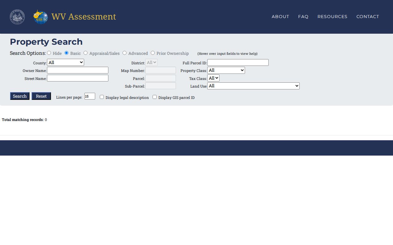
The result list can surface the legal description and GIS ID, but open the full card for its recorded reference and appraisal details.
Boone County Parcel Card Crosswalk
A Madison card shows why these fields belong together in your notes. It lists County as Boone, District as Madison Corp, Map 0010, Parcel 0018, suffix 0000. The same record carries Owner(s), all three address types, Book/Page, Deeded and Calculated Acres, and the legal description. It also breaks out Land Appraisal, Dwelling Value, Other Building/Yard Values, Building Appraisal, and Total Appraisal.
The sample shows .698 deeded acres against .73 calculated acres. Neither figure is wrong. Deeded acreage comes from the deed. Calculated acreage comes from map geometry, and the state says deeded acreage controls for assessment. Save the tax year too. Annual property records shift after a transfer or map update.
Open the Boone County parcel card to see the field labels used in this example.
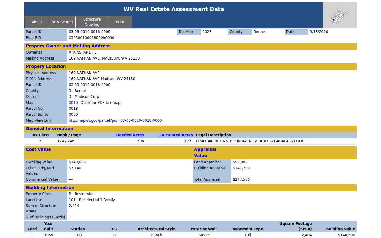
Note: treat the card as a field-reading example, not a substitute for the deed or a current survey.
Street Searches and Boone County Rural Parcels
Street Name earns its keep in a Boone County property search. It works when a block review matters more than one parcel. Results sometimes drop the road type, the direction, or the house number. Enter the distinctive road name alone. Then use the map and district to sort the parcels that return. The field list sets no hard result cap. The page does offer a Lines per page control if a long list needs trimming.
Rural tracts reward a different approach. Acreage may describe the land instead of a modern street. So may a creek, a road, or an older tract name. The E-911 address can sit blank on a state card even where local addressing exists. Trust the map and parcel pieces over a house number. Save the displayed Community and address exactly as shown. Compare those against the Root Parcel ID. Check the legal description too. Do not assume the mailing city names the tax district.
A recent split may not appear as a clean new shape right away. Assessment data refreshes once a year. The state requires map revisions for transfers between July 1 and June 30 to land by the next February 1. A line still wrong after two years is an assessor matter. Bring the deed or survey when you call.
Boone County Searches Include Entity Names
An assessment owner can be a person. It can also be an LLC, a corporation, an estate, or a public body. Punctuation and word order often differ across a deed, a parcel card, and a tax account. When a parcel names an entity, run the exact recorded name as a second search key. The West Virginia Secretary of State Business Organization Search offers Organization and Agent/Officer/Name fields. It also offers a percent sign wildcard for a distinctive name fragment.
A Secretary of State result can decode an entity name or surface a registered agent. The agent is not automatically the landowner. The deed stays the recorded transfer, and the Assessor keeps the current roll display. Public-entity cards in Boone County also show why class matters. A City of Madison parcel can carry Tax Class 4 and a C&A Addition description. A residential parcel shows different class and building fields. Search West Virginia business organizations whenever the Owner(s) field names an LLC or corporation.
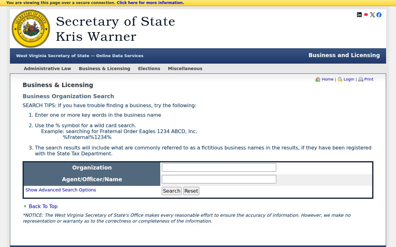
Treat the business search as an identity cross-check only. Then return to the Boone County instrument and parcel record for the answer.
Boone County Search Timing Has Two Clocks
Two clocks govern a Boone County property records search. The assessment roll and the recorded deed index do not move on one schedule. The Clerk may record a deed well before the next annual assessment release. Until the roll catches up, the card can still show the previous Owner(s). No fixed number of days defines that lag. Compare the latest deed date with the tax year on the card instead.
Maps follow their own path. A transfer that splits a parcel may require a submitted map revision. A mismatch lasting past two years belongs with the assessor. Keep both the deed reference and the map PID. Do not discard either after a hit. That habit matters most for a rural lot. It also matters for an older Madison addition. These may have a legal description nothing like their current street address. For a confirmed trail, carry the ID into the Boone County deed index workflow. Then weigh the newest conveyance against the assessment year.
Boone County Search Keys Compared
The best key depends on what you already hold. Address works for a house. Owner name suits a person or group with several parcels. A parcel ID is the strongest exact match once you have it. Boone County splits its numbers into district, map, parcel, and suffix pieces, so retain every zero and the full display until the portal confirms a short form.
| Search Key | Best For | Where It Works | Watch Out |
|---|---|---|---|
| Address | A known site or road | Assessment search and Viewer | Physical, E-911, and mailing text differ. |
| Owner name | Accounts tied to a person or entity | Assessment search and Clerk index | Try spelling, initials, trust, or LLC variants. |
| Parcel number | An exact tax-map account | Assessment, Viewer, Sheriff | Keep district, map, parcel, and sub-parcel parts. |
Not a title search. A Boone County property search helps identify records but does not guarantee clear title. Check recorded instruments and use a qualified title professional when a legal decision depends on ownership.
When a Boone County Address Search Misses
A blank result is not proof the land has no assessment record. The assessment form treats a street name differently from a parcel number and district. Its card also separates Mailing, Physical, and E-911 addresses. Enter the site address in the street field first. If that fails, fall back on a known owner or parcel key. One more trap: the postal city on a mailing line may not match the name of the land's tax district at all.
The state portal gives you other ways in. It filters by county, district, property class, tax class, and land use, and it can display a legal description or a GIS parcel ID. Start broad. Add one restriction at a time, because a wrong guess about class or district can hide an otherwise perfectly good record. For an older town lot, skip the modern street-address format and use an addition or lot reference taken from the deed.
When several nearby records crowd the results, compare the full district, map, parcel, and sub-parcel values instead of owner spelling alone. Keep every leading zero. Keep the complete suffix too. The parcel card is where a search result turns into a specific piece of land, and its legal description can separate a second parcel held by the same person from the first.
The state assessment form also lets you request extra display information, such as the legal description and GIS parcel ID, and set how many lines show per page. Those options change the view, not the assessment records themselves. A thin-looking result grid is not the final word. Open the card and confirm the record details before concluding a parcel is missing.