
Search Boone County Property Records
Start with whatever key you already hold. An address usually lands on the Assessor's statewide assessment card. A name may pull up several parcels at once. A parcel ID is stronger still. It carries the same tract from the tax map to the Sheriff ticket to the deed reference. On the Assessor card, look for the exact "Owner(s)" field. Mailing, physical, and E-911 address lines sit nearby. The card is a tax record, not a deed. The Boone County Clerk keeps the instrument that shows how title passed. The WV Property Viewer places the surface parcel on a map.
Jot down the district, map, parcel, suffix, legal description, tax year, and book/page. Do this as each result appears. Rural Boone County addresses can be incomplete or styled differently across systems. An older Madison deed may name an addition and lot. It may not use a modern street number. Maps point to parcels. When a map line or the acreage is in doubt, the recorded legal description and deed still win.
- Search the WV Property Assessment page by street name, owner, district, or parcel. Keep the full parcel ID and displayed legal description.
- Use the owner name or book/page to locate the instrument in Boone County WV Online Documents, linked from the County Clerk’s official records page.
- Check the Boone Sheriff Tax Office for a tax year, ticket, account, or district-map-parcel status.
- Open the parcel in WV Property Viewer, then compare its shape and map label with the legal description and tax map.
- For older or unclear material, ask the custodian for the volume, page, image, or Archives reel that matches the parcel.
Boone County Records Offices
No separate recorder-of-deeds office exists in Boone County. The County Clerk of the County Commission records land documents. The office also keeps the broader county archive. The Assessor builds the annual land book, parcel attributes, and local tax maps. Bills, tickets, and payment status belong to the Sheriff's Tax Office. The WV Property Tax Division runs the statewide assessment and map tools. A record is sometimes missing online. A parcel may have just changed hands. When either happens, the courthouse office and local mapping staff are the practical fallback.
Boone County Clerk
200 State Street, Suite 202
Madison, WV 25130
(304) 369-7330
Boone County Assessor
200 State Street, Suite 106
Madison, WV 25130
(304) 369-7313
Boone Sheriff Tax Office
200 State Street, Suite 102
Madison, WV 25130
(304) 369-7394
Boone County Property Record Types
One Boone County parcel can surface in several records. None of them answers every question alone. The Clerk's index points to recorded instruments. The assessment card ties an owner display to a tax parcel and its valuation, while the Sheriff record reports a bill or its payment status. A map links the assessment ID to a surface shape. City documents can add planning or floodplain context, but Madison's archive is not a parcel-indexed permit database.
| Record Type | What It Documents | Kept By | Access |
|---|---|---|---|
| Deeds, liens, plats | Transfers, recorded claims, lot descriptions, and references | Boone County Clerk | IDX link, courthouse, Archives for older runs |
| Assessment card | Owner(s), addresses, parcel ID, class, legal description, appraisal fields | Boone Assessor / WV Property Tax Division | Public statewide search; local correction help |
| Tax ticket | Tax year, ticket, account, paid or unpaid status | Boone Sheriff Tax Office | Online lookup or office confirmation |
| Parcel map | Surface parcel geometry, map number, flood context | Assessor / WV Property Viewer | Public viewer and GIS downloads |
| Estate and court records | Fiduciary authority, disputes, orders, and sale context | County Clerk / Circuit Clerk | Ask the custodian; Boone docket search URL not verified |
Match the record to the question. A transfer dispute turns on the deed image, not the assessment display. Tax questions split into two jobs. The Sheriff ticket tracks what is billed or paid. The Assessor card carries appraisal and parcel attributes. A legal description can tie both to the map, and the Boone County deed record route walks through the index and older book trail while the tax page covers the annual bill and appeal calendar.
Boone County Assessment Search Fields
West Virginia shares one assessment search statewide, and Boone County shows why more than one field matters. The modes include Basic, Appraisal/Sales, Advanced, and Prior Ownership. County and District narrow the jurisdiction. Owner Name and Street Name are practical starting points. When address text runs weak, Full Parcel ID, Map Number, Parcel, and Sub-Parcel do better, and results also surface legal descriptions and GIS parcel IDs.
The official search screen shows its inputs first. The parcel detail view appears only after a match. The two stages serve different purposes.
| Field | Where It Appears | How It Helps |
|---|---|---|
| County, District | Search select fields | Choose Boone and the taxing district. |
| Full Parcel ID, Owner Name | Search text fields | Use the root ID or try name variants. |
| Map Number, Street Name, Parcel, Sub-Parcel | Search text fields | Match a map part or review a road. |
| Property Class, Tax Class, Land Use | Search select fields | Filter or interpret the assessment type. |
| Display legal description / GIS parcel ID | Search checkboxes | Add cross-reference details to results. |
| Owner(s), Mailing Address, Physical Address | Assessment Detail result | Separate roll owner, tax mail, and site location. |
| Book/Page, Deeded Acres, Legal Description | Assessment Detail result | Bridge to a recorded deed and old map wording. |
| Total Appraisal and value parts | Assessment Detail result | Read land and building fields for the displayed year. |
Open the WV Property Assessment search to see the Boone County field layout itself.
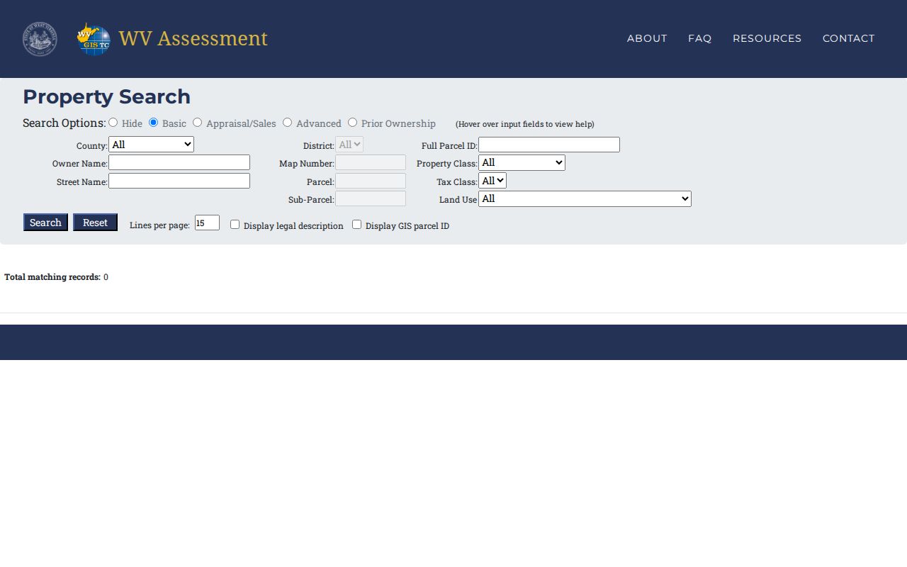
The search screen is only the start. The returned parcel card carries the book/page and legal description that later deed and tax checks rely on.
Boone County Parcel IDs Link Records
A full Root Parcel ID keeps every piece intact: county, district, map, parcel, and suffix. One Madison residential card reads 03-03-0010-0018-0000. That string breaks down as county 03, Madison Corp district 03, map 0010, parcel 0018, and suffix 0000. A Crook District sample runs 03-01-0018-0090-0001. Keep the leading zeroes, and let the form prove it accepts shorter versions. The Sheriff search instead asks for district, map, parcel, and sub-parcel as separate fields.
Once the ID is known, it joins systems that label it differently. Open the matching Assessment Detail card. Follow its map link and note the book/page. Search the Clerk index for the recorded instrument. The same district and parcel parts also drive a tax-ticket check, and rural Boone County addresses are less stable than this numeric route after a split or when physical, E-911, and mailing addresses disagree.
The sample Madison parcel card lays out separate owner, address, map, deed-reference, acreage, and value fields. Read the date and tax year alongside the name. An annual roll can lag. A recently recorded transfer may not show yet.
To compare the owner and legal-description fields side by side, open the City of Madison assessment card sample.
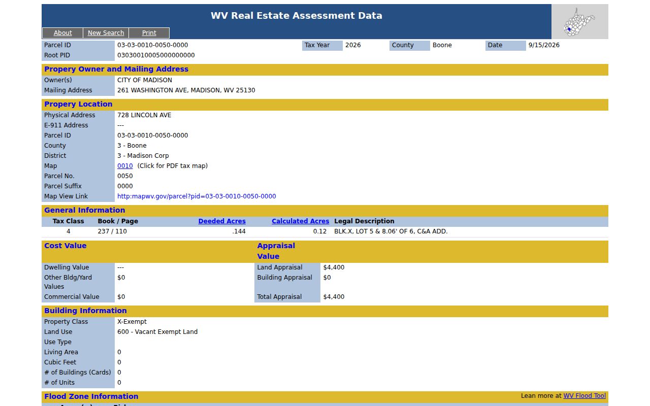
A public-entity card does not mirror a residential owner card. Check the owner type and tax class on any Boone County parcel before drawing a conclusion about the land.
Boone County Values Follow July 1
Boone County values real property at 60 percent of its estimated market value each July 1. That single date anchors the whole tax year. Assessment statements go out on July 15. They describe ownership as it stood on the previous July 1, not on the day the envelope arrives. Someone who bought land in August might see the deed recorded by the Clerk. Meanwhile the tax roll still lists the seller as owner of record. The statewide viewer refreshes assessment data once a year. So there is no fixed number of days to wait for the owner field to change. Patience helps here. The parcel map follows a slower clock of its own.
For transfers occurring between July 1 and June 30, assessors must submit map revisions by February 1 of the next calendar year. If boundary lines still look wrong after two years, the state recommends calling the assessor directly. A freshly split tract can show up in the deed records long before the plat catches up. In practice the deed records move first. When a boundary or parcel attribute needs fixing, Boone County Mapping will review the deed or survey in question.
Each date does a different job. The value date frames the roll. The statement date starts the bill cycle. The February map deadline governs parcel changes. Compare the same tax year across documents before reading two assessment cards as a trend.
Madison Additions on Boone County Maps
Madison's older parcel vocabulary leans on an addition name or lot number. It can also lean on a street rather than a modern subdivision label. Archived Map 8 names C&A Addition, Shields Addition, and Crawford & Ashby Addition. It also marks Washington, Virginia, and Jackson Avenues, Second and Third Streets, and civic buildings. It marks parcel numbers in circles and deed lot numbers in parentheses. It also notes right-of-way lines, parcel hooks, and a tax-purpose notice. Those labels help turn an old legal description into a map location. Do this before any deed-book search. The title block records 1960 aerial photography. It lists a map date of October 31, 1963, at one inch to 100 feet. It is a historical snapshot. It is not a current boundary survey. Use the addition and lot wording to search older instruments. Then compare the modern parcel card and recorded deed. The State GIS Clearinghouse distributes digital surface tax-map and GIS files at no charge. An individual county PDF carries its own reproduction notice. These map names also preserve record-era vocabulary. A present address may lead to the parcel. C&A or Shields can lead to the older lot language in the Clerk's index instead.
Older Boone County Deeds Beyond the Web
The WV Archives finding aid lists a Boone County deed index from 1847 through 1968. It also places deed records from 1847 through 1910 on film. Surveyor books run from 1840 to 1901. Trust-deed books run from 1871 to 1903. Land books cover 1888 to 1894. These are access leads, not proof that every page is online. When a web search stops short of the transfer in question, ask the Clerk or Archives. Request the right deed book, index, reel, or series. The reported 1861 courthouse burning is a reason to check custody and copies. It is not a reason to assume every early land record vanished. The finding aid shows continuing Boone record runs after that event. A careful note records where an image came from. It also records its volume and page. Note whether it is a county original, archive film, or copy. For older Madison descriptions, compare "Boone Court House" with "Madison." Then add the addition wording found on a tax map. View the WV Archives Boone County finding aid before requesting an older book or film series.
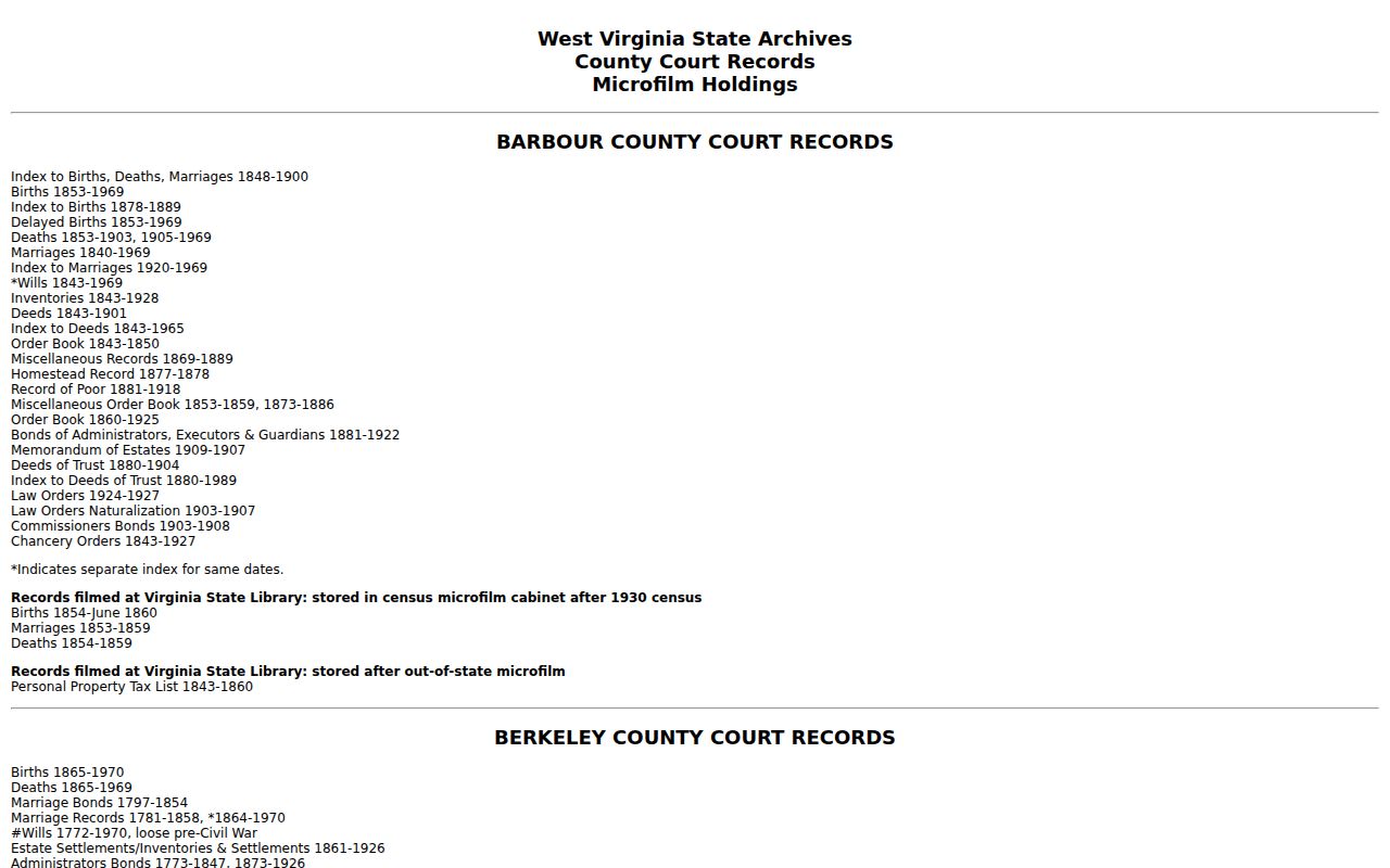
The finding aid narrows a request, and archive or Clerk staff can confirm the shelf, reel, and copy process.
Boone County Tax Tickets and Requests
The Sheriff Tax Office search accepts taxpayer name, account number, tax year, ticket number and suffix. District, map, parcel, and sub-parcel are accepted too. The search also has year limits plus Real/Personal and Paid/Unpaid controls. That tax ticket answers a payment question, not a title question. For delinquent land, the WV State Auditor's County Collections page searches state-certified records and land-sale stages. A map delinquency flag is a lead to verify with the Sheriff and Auditor. Live payment status can differ from the map layer. The official tax-sale material describes a certificate stage and a redemption period before a deed is issued. A listing or bidder certificate is not proof a sale is final. Ask the Sheriff for current ticket status. Ask the State Auditor for certified-to-state or sale details. Ask the Clerk for any resulting recorded deed. Confirm live status before sending payment or relying on a sale notice. For older maps, deeds, or files without a useful portal, the West Virginia Freedom of Information Act applies. It directs a request to the custodian holding the record. Section 29B-1-3 calls for a response as soon as practicable. The window is five days, excluding weekends and legal holidays. It allows actual reproduction cost only. No search or staff-time charge applies. Give the office a parcel ID, book and page, map number, date range, and requested format. Do not ask it to build a title report.
Boone County Address Fields Describe Different Places
A single Boone County parcel card can carry three different address lines. One is the physical, or situs, address, which points to the structure itself. A second is the E-911 address. It is built from local addressing data sent to West Virginia's Statewide Addressing and Mapping System. The third is the mailing address. That line tells you where tax notices go. It may be a post office box, a business, a public office, or even another home. It says nothing about who occupies the parcel.
An E-911 mismatch belongs with the local addressing office, not with a new deed. Changing a deed will not fix a wrong road name or emergency address. It should never be treated as evidence that the parcel card itself is wrong. The map's Community label and the tax District are also separate ideas. They are distinct from any postal city. Madison, Van, and other locality names show up in Boone County address context all the time.
If a location looks off, write down all three address fields. Also note the Root Parcel ID and the map link. That single note gives the Assessor or the local addressing staff what they need. From it, they can tell whether the problem sits in the site label, the tax mailing record, or the parcel geometry.
Boone County Delinquent Land Has Stages
A delinquent marker is not a finished transfer. Three different systems track three different things. The Sheriff's record shows tax-ticket status. The State Auditor's County Collections tools show certified-to-state land, listings, purchaser details, and redemption notices. Any deed that later conveys an interest gets recorded by the County Clerk. Each answers its own date-sensitive question. So a current owner field can stay unchanged while a delinquent process is underway.
Before acting on a tax-sale entry, write down the tax year, district, map, parcel, sub-parcel, certificate, taxpayer, purchaser, and status. Then confirm the paid or unpaid ticket with the Sheriff. And check the Auditor's sale and redemption information separately. A bidder registration form asks for contact fields and certifications. Those requirements govern auction participation only. They say nothing about whether a listed parcel is owned by a bidder. They also say nothing about whether it is free of other claims.
A certificate is not automatically the final deed. Payment, redemption, later notices, or a recorded conveyance can all affect the sale. Read Boone County records as a dated sequence. Check the tax office, the Auditor, and the Clerk one at a time.
Limits of Boone County Property Records
Boone County public records can answer many questions, but not all of them. They show the name on an assessment roll, recorded transfers, tax status, parcel geometry. Some court or probate context appears too. They do not prove who lives at a property. They do not guarantee clear title, set a market sale price, or settle a boundary. The viewer shows surface parcels. It states plainly that its lines serve tax and reference use. For assessment, deeded acreage controls over GIS-calculated acreage. When a line must be established on the ground, a licensed survey is required.
Names and addresses in a public record suit property diligence, house history, estate work. Civic review fits too. Telephone numbers and security-alarm details are redacted from state property-map data. Vital, juvenile, sealed, and protected records follow separate rules. For a suspected false deed or lien, compare the filing against the Clerk's index. Bring the question to the proper custodian or a legal professional rather than repeating an unverified claim.
Lawful use. Use Boone County property records for lawful property research and verification. Do not use owner information to stalk, harass, or harm another person.